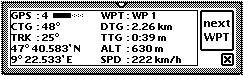
Navigation Information (GPS Map only)
Most of the screen area is used for displaying the map. There is an optional NAV information window which supports two operation modes.
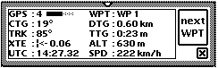
The meaning of GPS is the number of satellites tracked, CTG is the course to your goal, TRK is the actual course (over ground), WPT is the next way point, DTG is the distance to the way point, TTG is the time to the way point, ALT is the altitude (ovcer MSL), SPD is the speed over ground, XTE is the cross track error and UTC is the satellite time.
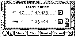
Moving the map
Normally the map will move automatically in such a way that the actual position will stay in the middle of the screen-fixed circle. For moving the map manually you have three choices:
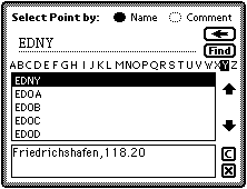
You can search both for the short name and the comment (e.g. Friedrichshafen).
GPS Map comes with a pre-loaded database with approx. 2800 entries. You may extend the database by entering new locations within GPS Map or by downloading them from your desctop PC.
GPS Map Lite has limited functionality and only supports up to six stored locations.
|
|
|