Huge waves from one storm slam coasts 6000 km apart
Huge waves that struck Reunion Island and
coastlines across Indonesia earlier this month all originated from the same
storm.
Huge waves that struck Reunion Island and coastlines across Indonesia earlier this month all originated from the same storm that occurred south of Cape Town, South Africa, and were tracked across the entire Indian Ocean for some 10,000 kilometres over a nine-day period by ESA’s Envisat satellite.
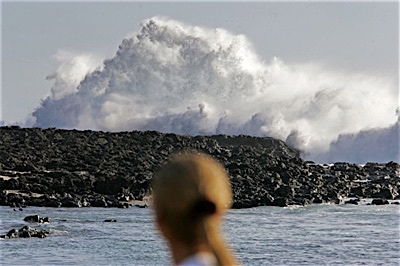
Waves reaching up to 11 metres devastated France’s Reunion Island in the Indian Ocean when it slammed into the southern port of Saint Pierre on 12 May. Six days later waves created from the same storm measuring as high as 7 metres began crashing into Indonesia coastlines from Sumatra to Bali, killing at least one person and causing some 1200 people to flee their homes.
“The extreme swell systems originated from the same storm, which moved rapidly and had two main strong wind periods,” Dr Bertrand Chapron said. “As illustrated in the animation, the resulting waves were organised into two main swell systems that followed each other across the entire Indian Ocean, hitting Reunion Island, Mauritius, Australia and Indonesia.”
Storms are capable of generating waves of different wavelengths that travel in several directions upon leaving the storm system, with the longest wavelengths travelling the fastest. As these waves cross open seas, they can accumulate energy at precise locations and become very dangerous for marine safety.
In addition, wave systems slow down as they approach the coastline, and individual waves increase to reach at least two times the mean average of their initial wave height. For instance, a 5-metre significant wave height system can hit the coast with the height of 10 metres.
The radar satellite tech used in this ESA project is pretty trick. Interesting read - and follow the links at the end of the article.
Posted: Sat - June 2, 2007 at 03:04 PM