Ready to go hiking on Mars?
Scientists using data from the HRSC experiment
onboard ESA’s Mars Express spacecraft have produced the first
‘hiker’s maps‘ of Mars.
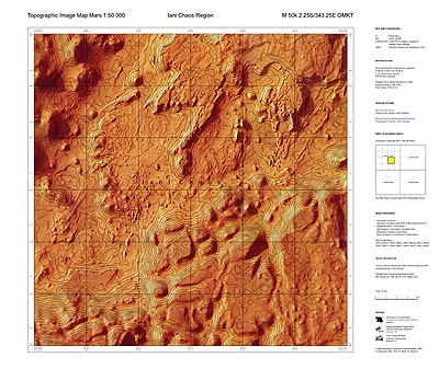
Scientists using data from the HRSC experiment onboard ESA’s Mars Express spacecraft have produced the first ‘hiker’s maps‘ of Mars. Giving detailed height contours and names of geological features in the Iani Chaos region, the maps could become a standard reference for future Martian research.
The maps are known as topographic maps because they use contour lines to show the heights of the landscape.The contour lines are superimposed upon high-resolution images of Mars, taken by the High-Resolution Stereo Camera (HRSC) onboard Mars Express. On Earth, such maps are used by hikers and planning authorities.
They are known in the UK as ordinance survey maps. Every country has its own equivalent. The contour lines themselves were determined using data from the HRSC.
I’m ready! Just get me there.
Posted: Wed - February 14, 2007 at 07:06 AM