Earth From Space: Sandstorm In Rajasthan, India
A sandstorm obscures the border zone between
Pakistan and India's desert state of Rajasthan in this Envisat
image.
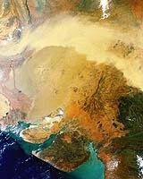
Much of the north-western portion of Rajasthan is covered by the inhospitable and thinly-populated Thar or Great Indian Desert, which also extends into Pakistan. Wind-driven sandstorms rising in the Thar are a common feature of the harsh January to June dry season.
Don’t click on the larger image link at the SpaceDaily article if you don’t have broadband. It’s a 7.5mb .tiff!
This 10 June 2005 image was acquired by Envisat's Medium Resolution Imaging Spectrometer (MERIS), operating in Reduced Resolution mode to provide a spatial resolution of 1200 metres. The image covers an area of 1943 by 1943 kilometres.
SpaceDaily is one of my favorite sources -- after Simon’s TerraDaily. He gets really uptight if you holler at him about the pernicious pop-unders and garish adverts. It’s how he lives, after all -- and keeps all this good info flowing. I imagine his subscription to AFP costs a bundle. Certainly, the Santa Fe NEW MEXICAN hasn’t decided to spend the bucks for such a viable alternative/addition to the AP.
Posted: Mon - August 29, 2005 at 07:56 AM